In accordance with the Planning and Building Act Section 12-8, notice is hereby given that ViaNova Kristiansand AS, on behalf of Kristiansand Port IKS, is initiating work on detailed regulations for the expansion of the port area in Kongsgård /Vigebukta in Kristiansand municipality.
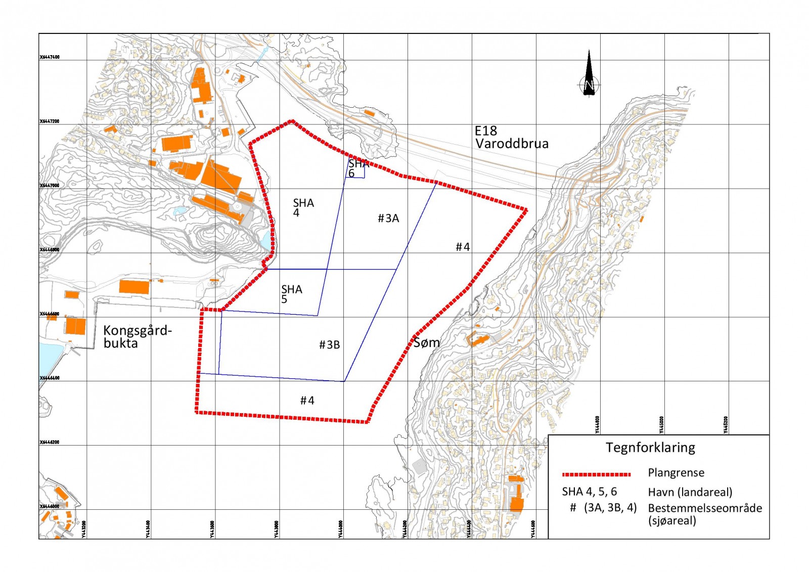
The planning area is approx. 542 daa, and includes properties gnr/bnr 47/3, 16, 17, 23 and 385, and associated sea areas outside. In the west, the planning boundary follows Vige Havnevei, in the north towards E18, in the east towards Søm and in the south outside Kongsgårdbukta. The area includes fields SHA4, SHA5, SHA6, parts of VHS and parts of VFE, cf. municipal sub-plan for the northern harbour area, Kongsgård -Vige. The planning boundary has been determined by Kristiansand Municipality after the kick-off meeting on November 18, 2021. During the planning work, the area may be further delimited.
The proposed plan boundaries are shown on the map below.
The purpose of the regulation is to facilitate the future expansion of the port as adopted in the current municipal sub-plan. The plan includes stabilizing rock fillings on the seabed. The fill will be filled up to a maximum of 5 meters below sea level. The entire measure will lie below sea level and will thus not be visible above sea level.
The planning process will address the need to investigate water flow through the planning area in Topdalsfjorden, registration of biodiversity in the planning area in Topdalsfjorden, ground surveys and geotechnical assessments of stability in areas of brittle fracture. In addition, conditions relating to ancient monuments in the sea, noise and dust when handling stone, interface with E39-E18 Ytre Ringvei, pollution in the sea (stone filling), sedimentation of the seabed and the stage of filling.
Relevant purposes in the new plan could be "Port, Port area in the sea, and Traffic".
In the municipal plan's area section 2011-2022, the areas are allocated to "Current port", "Current traffic" and "Combined purpose in sea and waterways with or without associated shore zone". In the "Municipal sub-plan for the northern port area, Kongsgård -Vige" (adopted by the Ministry of Local Government and Modernisation on 25.06.2020) with plan ID 1441, the area is allocated to "Port (SHA), Port area in the sea (VHS) and Traffic (VFE)". Kristiansand Municipality recommends the start of planning work.
The proposal for detailed regulation for Havneområde nord Kongsgårdbukta, has been assessed in relation to the requirements in PBL of 2008, as well as regulations on impact assessment §§ 6 and 8. Kristiansand municipality concludes in a start-up meeting on 10.11.2021 that the planning work triggers a requirement for an impact assessment, but not a planning program, according to PBL § 12-3, cf. § 4-2.
At the same time, notice is given that negotiations will be initiated on a development agreement for the area in question, cf. section 17-4 of the Planning and Building Act. The agreement applies between the parties concerned (the developer or landowner and the municipality) and regulates the relationship regarding the development of the area.
Any views, comments, information that may be of importance to the planning work or the development agreement are marked with "detailed regulation" Kongsgård – Vige harbor area, SHA4, SHA5 and SHA6" and sent in writing by 28.01.2022 to:
ViaNova Kristiansand AS, Gyldenløves gate 1C, 4611 Kristiansand or Email:
Email: even.lorentsen@vianova.no
Phone: 916 55 848